


Hidden Gems: Top 3 Most Underrated Ozarks Waterfalls
Disclosure: Opinions, camping practices, and experiences expressed with articles posted here or otherwise via user-generated content posted elsewhere on this site are solely the authors’ and do not reflect the opinions, beliefs, camping practices, or experiences of this website or Camping Tools, Inc.

People drive hundreds of miles to visit a good waterfall.
Each state boasts its own famous falls that draw in outdoor adventurers like moths to a flame, with some of the most prestigious receiving millions of tourists each year.
Unfortunately, excessive visitation can pose some issues. Waterfalls get crowded and decidedly un-magical. Parking areas and trails are overrun with trash, and once-pristine locations become loud and dirty.
Want to avoid all that? Get off the beaten path.
Here in the Ozarks, we’ve got hundreds of underrated waterfalls that are even more stunning for their solitude. Some of the best include:
- Broadwater Hollow and Paige Falls
- Steele Creek Falls
- Six Finger Falls
Read on to discover tips and tricks for visiting these top-tier Ozarks waterfalls, including how to navigate the trails and where to camp nearby.
1. Steele Falls
Waterfall Height: 66 feet | Trail Length: 2.7 miles | Difficulty: Moderate
Steele Falls is often overlooked for more popular area attractions like Blanchard Springs Caverns and Gunner Pool. But for those willing to drive the extra mile or two, the reward is magnificent.
Steele Falls is hidden deep in Ozark valleys. It’s one of the tallest falls in the state, reaching up to surprising and stunning glory from an unassuming glen.
You’ll need to head deep in the backwoods for this one, so get ready for some dirt roads.
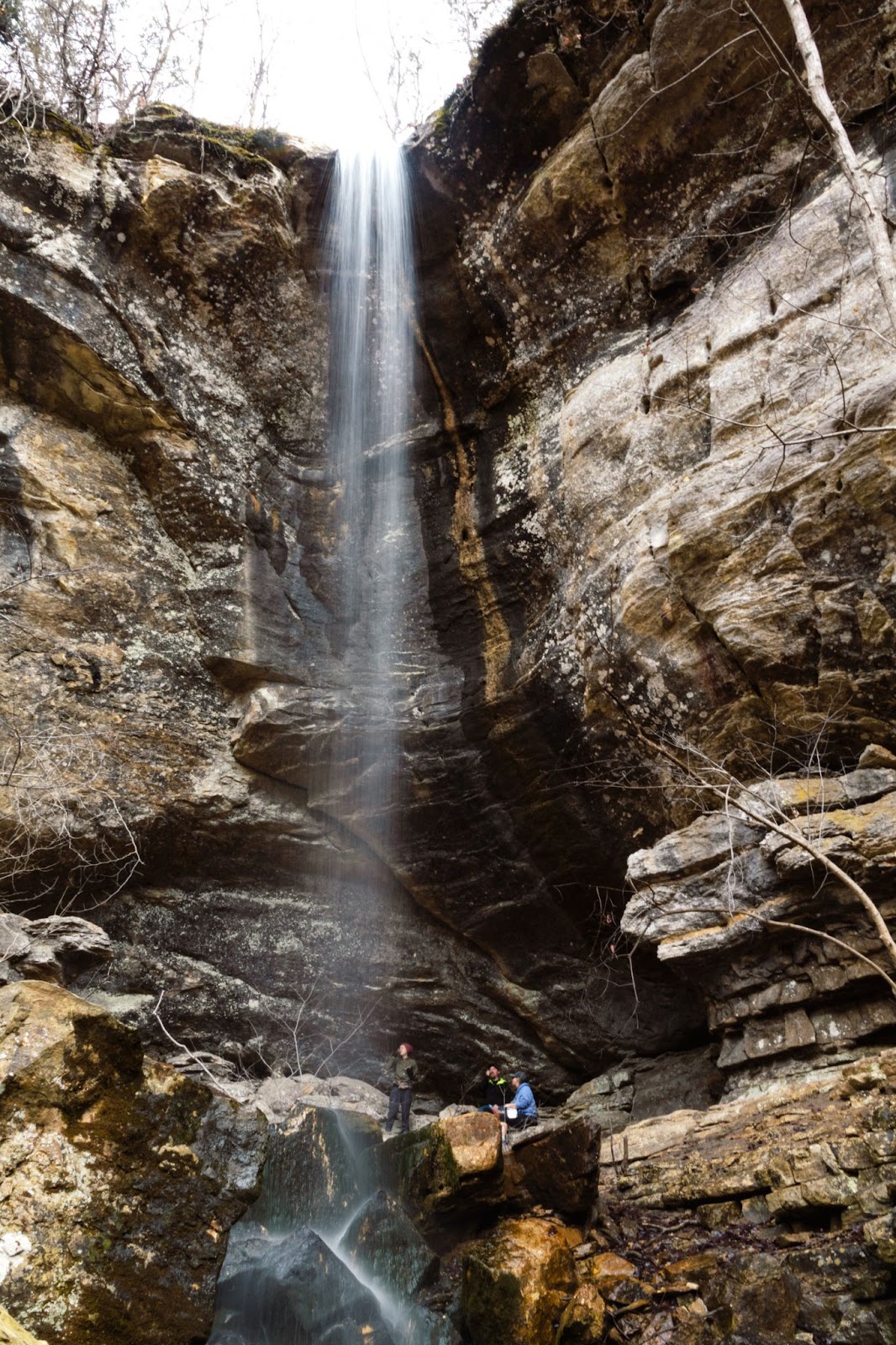
You wouldn't expect to find such a tall waterfall here, but these hills hold secrets it would take a lifetime to discover.
How to Get There
GPS: 36.014873534566384, -92.19109494729614
Steele Falls is located in the Sylamore Wildlife Management Area between Calico Rock and Mountain View, Arkansas. This wilderness spans thousands of acres snaked with winding forest service roads throughout.
It’s easy to get lost. I don’t get any service in Sylamore WMA, so you can’t always rely on Google — it’s critical to know where you’re going beforehand.
There are a few ways to reach the trailhead, but some are rough and unsuitable for two-wheel drive vehicles and RVs. To ensure you (and your car) get there in one piece, it’s best to approach one of two ways.
Via HWY 14: Your first option is to approach from the south via Gunner Pool Road off Highway 14. From Mountain View, you’ll head north on AR-87 for 10 miles and take a left on AR-14. After around three miles, you’ll take a right on Gunner Pool Road, a fairly decent dirt road.
Go about six miles on Gunner Pool Road, then head right on Green Mountain Road (FS 71). After about a mile, you’ll notice a bald patch on the left side of the road where you can park.
Via HWY 5: Your second option is to approach from the north via Gunner Pool Road off Highway 5. Head south on Highway 5 from Calico Rock for about five miles, then take a sharp right on Gunner Pool Road. Yes, it’s the same road you take approaching from the south; it passes clean through the wilderness!
Go about 4 miles on Gunner Pool, then take a left on FS 1113. You travel about a mile, then take another left onto FS 93. You’ll then take a left on FS 71, where you’ll find the little bald parking area to drop your vehicle.
The Trail
Once you park, you’ll see a gated forest service road at the front of the lot. That’s the trailhead. It isn’t apparent or well-marked, and it doesn’t peter out to an actual trail until the very end — it’s just an old road.
The trail is an out-and-back hike that’s about 2.7 miles altogether. It isn’t difficult, but you’ll experience a solid 400-foot elevation change along the way, and the most challenging part is the uphill walk returning to the car.
You’ll see some cool rock formations, but the trail isn’t extraordinary. I think the fact that it’s a road takes away from the hiking experience. However, the fall at the end is well worth the trek.
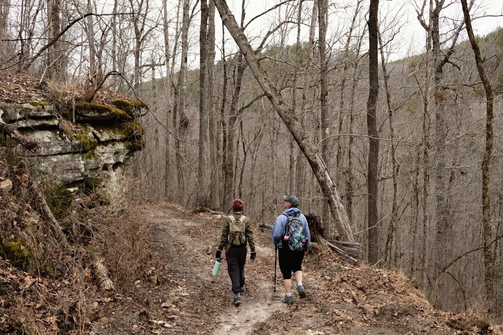
The trail does have its charming moments, despite being a glorified forest service road.
Camping Nearby
Dispersed camping is allowed in almost any area of Sylamore WMA, including at the trailhead. You can park your RV here and relax but don’t expect any amenities.
For a more civilized experience, you can head up to Blanchard Springs Campground. You’ll be greeted with water hookups, flush toilets, and trash service for $15 per night. No electricity is available, but it’s still a great deal — you get to camp next to the spring, and the sites are well-maintained.
There are also several private campgrounds and Airbnbs in the area if you want a more luxurious experience.
2. Broadwater Hollow & Paige Falls
Height: 6 / 21 feet | Trail Length: 0.3 – 7+ miles | Difficulty: Easy - Hard (via approach)
You won’t find the National Park Service boasting about Broadwater Hollow and Paige Falls. There is no trailhead and zero signage to point you in the right direction.
Despite this, the area remains a favorite waterfall destination among locals. Once you get there, you’ll see why.
Broadwater Hollow is a marvelous maze of ancient boulders and soft, green moss. Each step takes you back in time, the distant white noise of water becoming louder as you venture on.
The hollow boasts a series of three waterfalls, each more magnificent than the last. Paige and Broadwater Hollow Falls are chief among them, but each cascade is a magical scene of its own you have to see to believe.
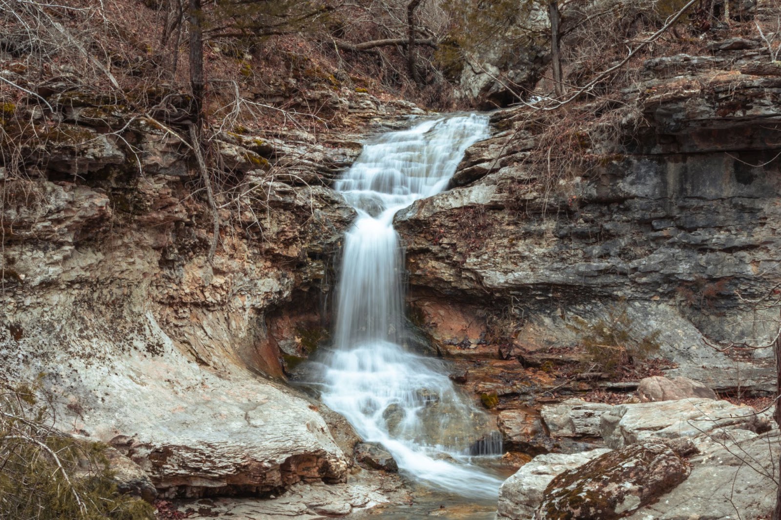
Broadwater Hollow Falls reaches an impressive 21 feet.
How to Get There
GPS: 36.105173301598875, -93.26670521194951
Broadwater Hollow and Paige Falls are located in the Upper Buffalo Wilderness Area near Compton, Arkansas.
From NC 2660: From Compton, head north on AR-43 for a half-mile. Then, turn east (right) on NC 2660 and drive about 2.5 miles. You will cross a low-water crossing and see the road dead-ends onto private property. Park and walk towards the water on the righthand side. You will see a footpath which will lead you to the falls.
From Cecil Cove Loop: You can also reach Broadwater Hollow and Paige Falls from the Cecil Cove Loop Trail near Erbie. This will turn your short excursion into a full day of adventuring, but it’s a gorgeous and very secluded hike.
You can reach the Cecil Cove Loop Trail from Compton by heading south on AR-43 and east (left) on County Road 19. Stay on CR 19 for 6.5 miles; you’ll see the trailhead on your right. I’d recommend a 4X4 vehicle if you want to go this route. I’ve made it with two-wheel drive, but barely.
If you don’t have a 4X4 but still want a longer hike, get to Cecil Cove Loop Trailhead via the Erbie Cutoff Road from Highway 206. Or, pass through Erbie Campground itself by taking FS 79 off Highway 7 near Jasper.
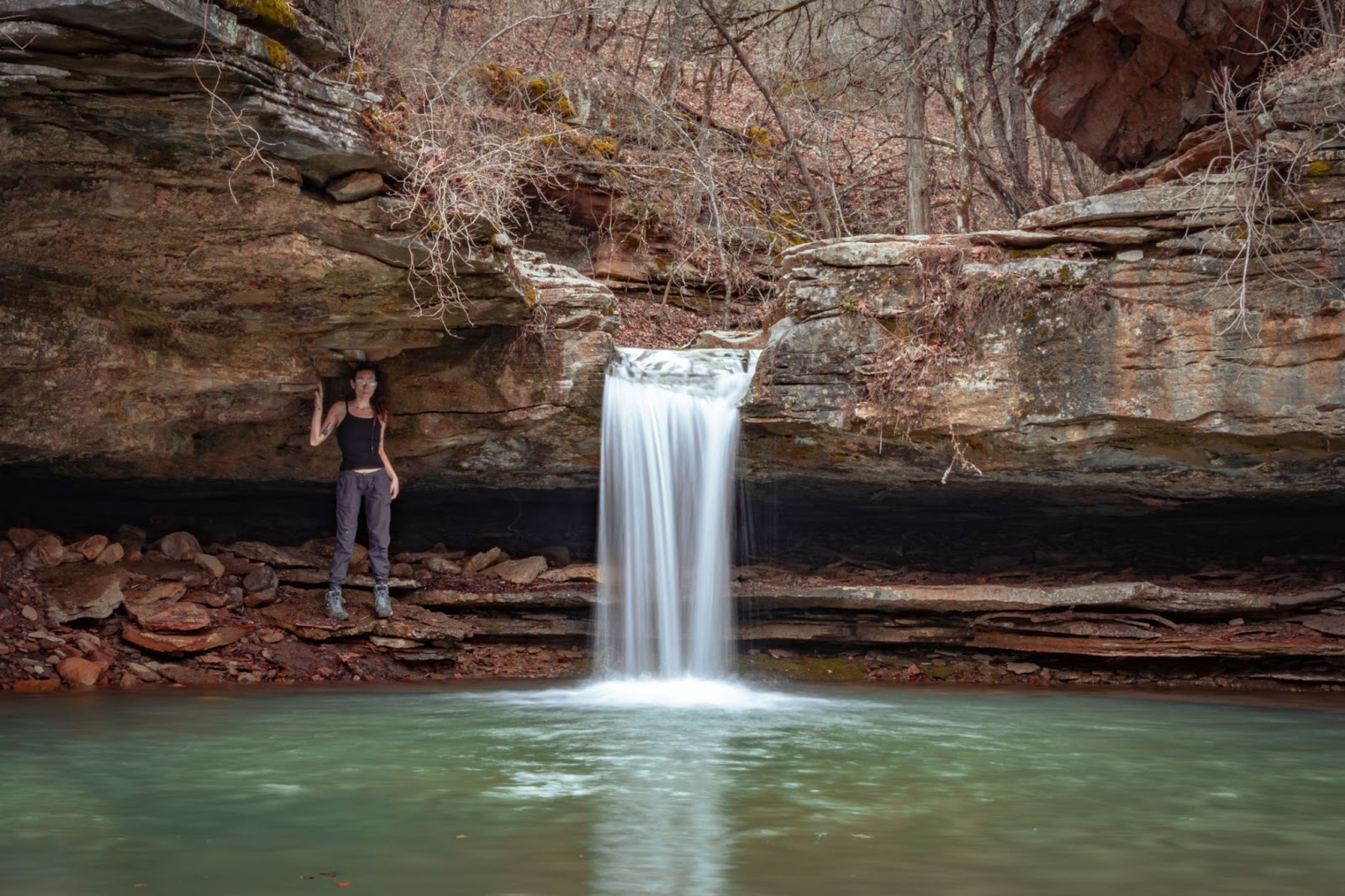
Paige Falls makes up for its smaller stature with awestriking beauty.
The Trail
The trail is not well-marked from either direction.
From NC 2660 it is short but moderately steep and slippery. It heads straight down towards the falls. You’ll see pink tape tied around some trees to mark the trail on the road and along the way. That’s all you get, so pay attention.
From Cecil Cove Loop, you’ll see a trailhead with a map and an obvious trail. However, Broadwater Hollow itself is not featured as a waypoint, so you must pay attention. There are several low-water crossings along this trail, and in the high season, you will need to cross some knee-deep (or deeper!) water.
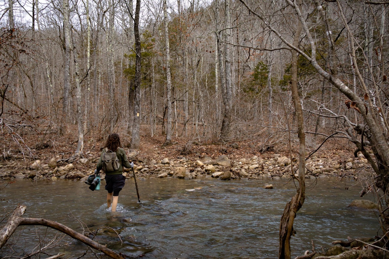
Be prepared for shockingly cold creek crossings if you hike the Cecil Loop Trail during winter or spring.
You’ll walk the trail for about three miles, then continue right at the fork with signage marking the bench trail return loop and Jones Cemetery. You’ll pass Cecil Cove and begin to see pink tape tied to trees. Follow the tape-marked trail, which turns into Broadwater Hollow and leads you to the falls.
On your way back, you can visit the historic Jones Cemetery, but do not attempt to complete the loop. A recent landslide has wreaked havoc on the trail, and the return loop is impassable.
I ended up climbing over the landslide since night was falling, and we needed to leave the area ASAP. However, this is unsafe and generally ill-advised.
No matter what direction you come from, be prepared to climb around on boulders for the best views and perches for swimming!
Camping Nearby
The best campground nearby is Erbie Campground, hands-down the best free campground I’ve ever visited.
RVs are easily accommodated here but will need to approach via Highway 7 near Jasper. Make sure to plan accordingly since the low-water crossing that connects Erbie Campground and the Cecil Cove Loop Trail is sometimes unpassable after rain.
Erbie Camp actually made my list of the best budget campgrounds in the Buffalo River Wilderness. You can discover more about Erbie and other spectacular hidden freebies by signing up at camping.tools and checking out the in-depth campground reviews by campers like you.
3. Six Finger Falls

Waterfall Height: 6 feet | Trail Length: 0.1 miles | Difficulty: Easy
Don’t feel like hiking? Head for Six Finger Falls. This breathtaking waterfall lies right off the road, albeit the one less traveled. You won’t need 4X4 to get there, but it is definitely made of dirt, and RVers are encouraged to leave tow-behinds at the basecamp before making the drive.
The waterfall is a short stack standing just six feet tall yet clocking an impressive girth of over 100 feet.
Unusual, step-like stones form the six-fingered base of this gentle cascade, and many visitors enjoy splashing in this staircase to heaven on a hot day during the low season.
How to Get There
GPS: 35.762020312537544, -92.93756998819364
Six Finger Falls is located in the Richland Creek Wilderness near Pelsor and Witts Springs.
From Witts Springs, head south on AR-16 for about 1.5 miles. You’ll then turn right on Richland Creek Road, AKA FS 1205, AKA CR 68. You’ll see a sign for the Falling Water Horse Camp. Continue for about 5.5 miles.
You’ll pass over a bridge above Falling Water Creek and continue for about half a mile until you reach the dirt parking area. The falls will be on your left.
The Trail
There isn’t really a trail here. Just park your car on the side of the road and head to the overlook! You can hike down from there if you want to play around in the falls. It’s a relatively simple climb, but make sure to watch your step.
If you want to hike around and explore the area more, take the nearby horse trail to Fuzzy Butt Falls or drive to Falling Water Creek to catch the Falling Water Falls (original, I know) just up the road.
Camping Nearby
If you are tent camping, the nearby Richland Creek Campground offers sites for $10 per night with water and vault toilets. Because of the rough roads, RVers are discouraged from using this site. I’ve never camped in an RV here, but I have seen many brave souls drag their rigs down for peace and quiet.
You can also take advantage of free dispersed camping at numerous pull-in sites throughout the wilderness area.
If you’re looking for more amenities, you must head further away. The nearest full-service campground with electricity, water, and trash service is Mack’s Pines. They are about half an hour out and have a café and cabins available for rent.
Tips for Visiting the Top Waterfalls in the Ozarks
Here are some things to keep in mind as you prepare to go chasing waterfalls:
- Time of year: waterfalls flow best in the spring and can dry up to nothing in the summer. Plan your trip after a rainy period to ensure you get a stellar view.
- Day of week: even the road less traveled can become clogged with adventurers. If serenity is what you’re after, plan your visit on a weekday to avoid smatterings of people.
- Weather: you want to go after a rain, but not after a monsoon. Dirt roads can get washed out, muddy, and downright dangerous, especially with a sizeable rig.
Want to start planning your adventure? I can’t blame you! Now that you know about the top three most underrated waterfalls in the Ozarks, you can explore these hidden gems as soon as the weather gets nice.
No comments added


Recent Stories
A Quiet Season of Opportunity March sits in the quiet space between winter and spring—when campgrounds are empty, bugs are blissfully absent, and the weather can’t quite make up its mind. For campers willing to plan ahead, it’s one of the most rewarding times to be outdoors. Fewer crowds, fresh landscapes, and a slower pace make this month ideal for intentional, low-stress adventures. Expect the Unexpected The biggest challenge of March camping is variability. One weekend feels like spring, the ...
March Break is a great time to get kids outside and enjoy early spring adventures. Shorter days and unpredictable weather make preparation key. Here are ten quick tips to keep your family safe, warm, and having fun: Layer Up – Dress kids in moisture-wicking base layers, warm mid-layers, and waterproof outer layers. Don’t forget hats, mittens, and extra socks. Warm Sleeping Gear – Use sleeping bags rated for cool temperatures and insulated pads to keep everyone cozy at night. Choose Kid-Friendly ...
