


Ozark Views: 3 Unforgettable Fall Hikes in the Buffalo Wilderness
Disclosure: Opinions, camping practices, and experiences expressed with articles posted here or otherwise via user-generated content posted elsewhere on this site are solely the authors’ and do not reflect the opinions, beliefs, camping practices, or experiences of this website or Camping Tools, Inc.

The Buffalo National River Wilderness is one of the most popular hiking areas in the Ozarks. High bluffs and spectacular rock formations draw in visitors no matter the season, but autumn is an especially great time to go. Many trails that are congested with overgrowth in the spring and summer open up nicely in the fall. And since the foliage along cliffside paths thins out this time of year, you can see spectacular mountain vistas while the colors are changing.
Here are the 3 best fall hikes in the Buffalo National River Wilderness:
- Big Bluff Goat Trail
- King’s Bluff Loop
- Hawksbill Crag Trail
Many Ozark natives believe that fall hiking is superior in all regards. Not only is it beautiful, it’s also more comfortable. Awestriking reds and yellows paint the landscape, pesky insects disappear, and hikers can expect respite from brutal summer temperatures. You might still break a sweat on these trails, but that’s all part of the fun! Without further ado, let’s get exploring.
A Bit About the Buffalo National River Wilderness

Big skies, big bluffs, and big colors characterize the Ozarks in autumn
The Buffalo Wilderness contains around 36,000 acres of ridiculously good-looking landscape. This land lies in the heart of the Ozarks, with unique terrain formed millions of years ago by the natural process of erosion. The bluffs here are a unique geographical wonder made even more spectacular by the rushing waters of the Buffalo River. The entire area is a gigantic playground with hiking trails galore, each offering up a special taste of rugged beauty for the intrepid explorer.
There are three distinct wilderness area units which lie along the river: the Upper Buffalo Unit, the Ponca Unit, and the Lower Buffalo Unit. The Buffalo Wilderness is free and open for anyone to explore. While pets are not permitted on most of the trails, backcountry camping is encouraged. If you do bring your tent, check to see if there’s a burn ban on before you make a fire. And bring a camera with you to capture this slice of heaven on film.
3 Best Fall Hikes in the Buffalo Wilderness Area
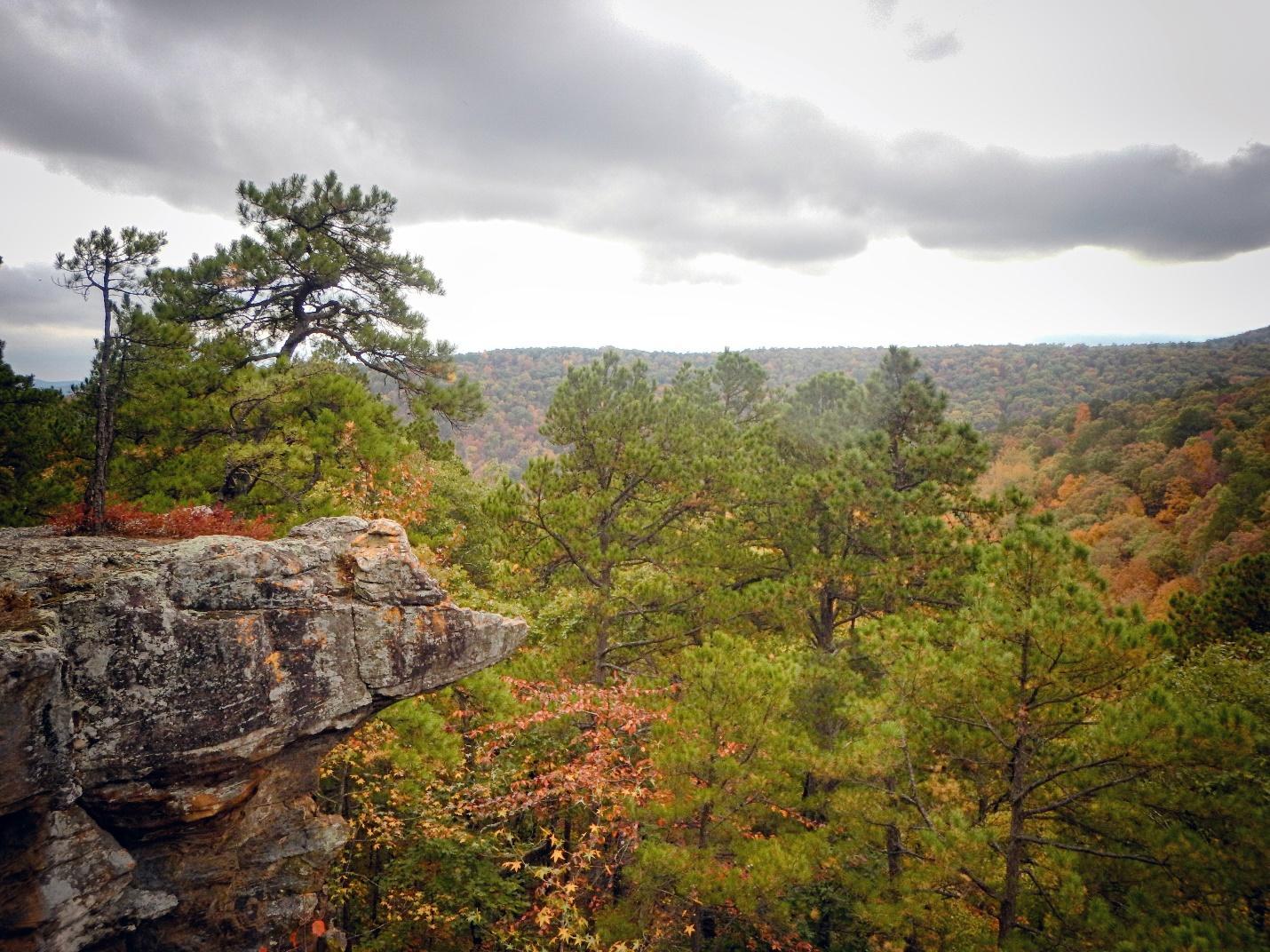
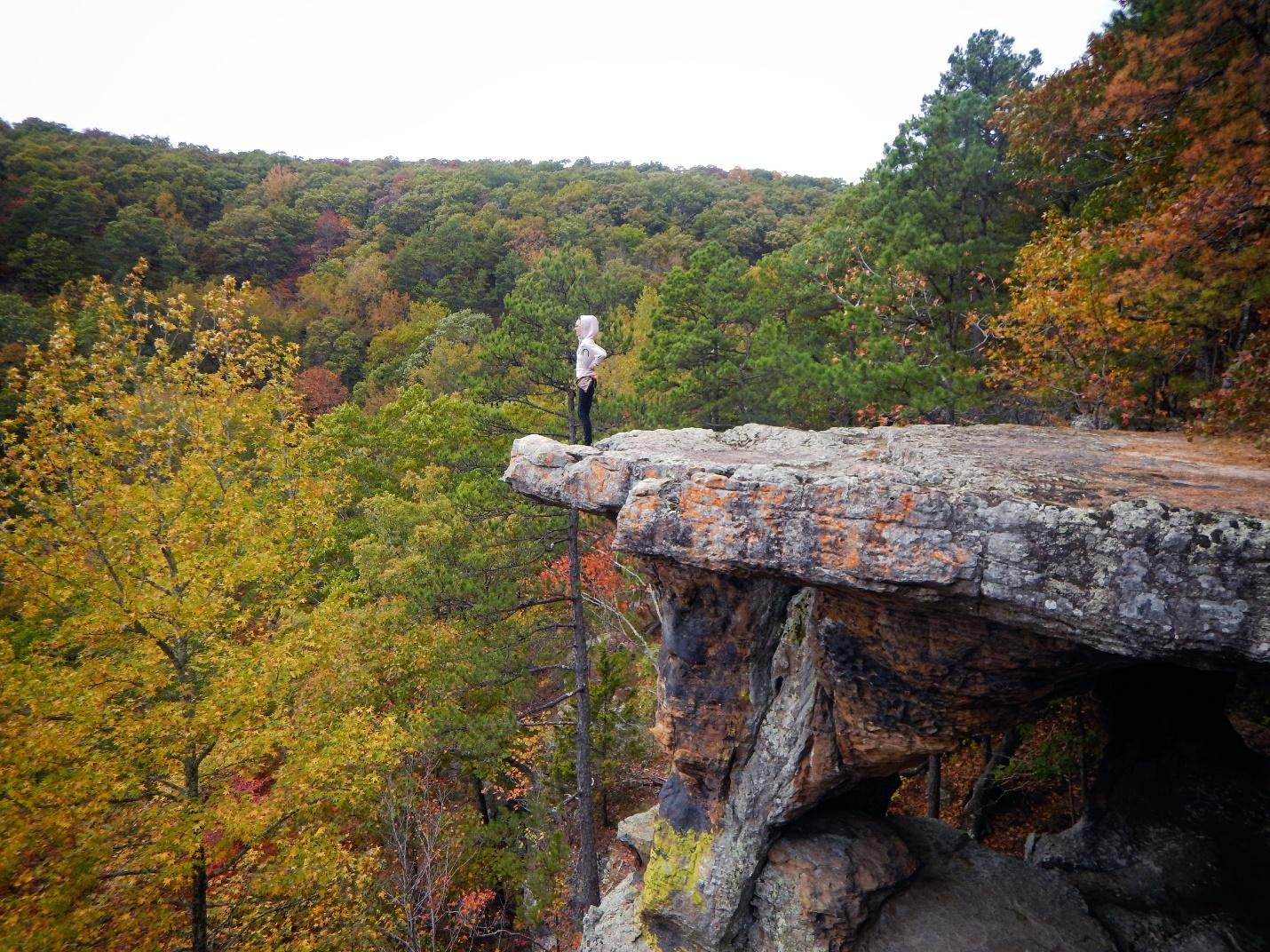
1. Big Bluff Goat Trail
Length: 6 Miles Total | Difficulty: Difficult | GPS: 36.06465709383133, -93.359051398841
The National Park Service could have chosen a better name for Big Bluff. They were probably too busy picking their jaws up off the floor to get creative, but we can forgive them. After all, the bluff is big. At 350 feet, it’s the tallest known bluff in the Ozarks. It also boasts a stunning 180-degree panorama of the Buffalo River Valley and the winding riverside rocks which rise above.
How to Get There

Enter another world to see stunning scenery along the bluff
To access Big Bluff, you’ll need to start at the Centerpoint Trailhead in the Ponca Wilderness Unit. From Ponca, head north on Highway 43 about three miles until you reach Fire Tower Road. The parking lot for the trailhead is right across the street. Keep in mind you might lose cell service out here, so plug in the coordinates ahead of time if you’re using a GPS.
Unfortunately, this gravel lot cannot accommodate RVs, trailers, or more than around 15 vehicles. It’s incredibly cramped, so arrive during the week or very early in the morning to get your spot. If you get there late, don’t sweat it. The people across the street run a horse camp, and they’ll let you park there for $5.
Hiking the Trail

Fall colors along the Centerpoint Trail
Once you conquer the parking situation, it’s time to get your feet on the trail. It’s a pretty cool route, as it follows an old wagon road for much of the way. You can see some vestiges of pioneer-era life along the trail, including some old berm-style storage sheds built into the hills. You can also see newer vestiges. My favorite is a 1950s washing machine which sits rotting in the middle of the forest.
After about 2.5 miles hiking from the Centerpoint Trailhead, you’ll reach the Goat Trail. It is a spur of Centerpoint which takes you out onto Big Bluff. Veer towards the right at the fork and get ready to scramble over rocks and beneath cedars before you finally hit pay dirt.
The View

Big Bluff boasts big views for miles
Once the view opens up at the bluffline, you’ll see why this hike is so amazing. The path spans a mile-long curved ridge offering a unique vista of both east and west. The Buffalo River runs distantly below, and you’ll be able to see the lower bluffs snaking away in both directions.
Out on Big Bluff, there might be dozens of people. I never really notice them. For me, being out here is a singular experience. This view makes my heart catch in my throat. It takes away the problems of the world, reducing each anxious insecurity into a foolish and miniscule care.
It’s as if we enter another era, one where the primary driving force is geologic instead of political. I sit and stay for as long as I can, halfway expecting a pterodactyl to come careening around the cliff. When this inevitably fails to occur, I devour some jerky and begin the 2-hour hike back up.
It’s no easy climb. You’ll gain 1300 feet of elevation on the way back, and the terrain isn’t easy. You’ll need to contend with loose rocks and sharp gravel until you get to the trailhead once more. This hike is not for the faint of heart, but it’s worth the effort.
2. Kings Bluff Loop
Length: 2 Miles Total | Difficulty: Easy | GPS: 35.7300386730505, -93.01383936324392
The Kings Bluff Loop is a relatively easy hike. The Trailhead has two spurs, one for Pedestal Rock and another for King’s Bluff. Both are worth doing, but the autumn views are best from Kings Bluff. The entire area sits atop the Illinois Bayou River Drainage, and you can see thousands of layers of sediment leftover from when the mountain was under water. Over the past few millennia, weathering has caused the sediment to separate from the main bluffline in a series of incredible formations.
How to Get There
Dozens of rock outcroppings jut out from Kings Bluff
Kings Bluff Loop lies within the Pedestal Rock Scenic Area. This technically falls under the jurisdiction of the Big Piney Ranger District, but it connects with the Upper Buffalo Wilderness and lies less than an hour from Ponca by car. Like many areas in the Ozarks, you won’t get any cell phone service here, so plan accordingly. To arrive, you’ll need to head to Sand Gap.
Neither sandy nor with a prominent gap, the town nevertheless lies at the junction of AR HWY 16 and HWY 123. When you reach the junction, take HWY 16 eastward for six miles. You’ll see a big sign for the trailhead. You can park a car, truck, or RV here. I’ve never had a problem parking, as the lot is big and rarely crowded. Unlike Big Bluff, Kings Bluff boasts lots of privacy and ample room to roam alone.
Hiking the Trail

Ethereal beauty surrounds the Pedestal Rocks
Once you park, you’ll be able to locate the trailhead to the right of the vault restroom. It’s a pleasantly-shaded path lined with blackgums, maples, and beech trees. You’ll see a smaller path veering off towards the right. That’s the feedback from the Kings Bluff loop. Once you walk for about a quarter-mile, you’ll see a three-pronged split in the trail.
The path on the left will take you to the Pedestal Rock loop, while the one on the right leads you to Kings Bluff. The one in the middle is the feedback from Pedestal Rock loop. You can choose to hike one loop or both. If you’re here already, the Pedestal Rocks are definitely worth the extra two miles. But if you’re pressed on time during the fall season, take the path on the right to see crazy colors in action.
The View
The colors on Kings Bluff just don’t quit
The trail itself is easy walking. The path does narrow in places, and the terrain does get steep in parts. It’s pretty, but not incredibly remarkable until you reach the bluffline. This 114-foot-high cliff spans hundreds of meters of open space, providing some of the best views in the region. During the fall, the color palette here is much more intense than on Big Bluff or Hawksbill Crag—that’s because of the dense population of maple, oak, and sassafras trees located in the valley.
The Kings Bluff Loop is only about two miles, but you may catch yourself spending all day here. The unique pedestal-shaped rocks along the bluffline are a captivating sight, and the vista looks like something out of a tourist guidebook. Sunrises and sunsets generally look amazing from here, but you can also catch a nice sunny filter around three in the afternoon.
If you choose, you can head off the trail and walk down into the valley below Kings Bluff. The rock has eroded so much down there that the entire bluffline is really just a series of shallow caverns, arches, and walkways. You can spend hours or even days exploring these murky chasms. The sunlight rarely reaches the forest floor, and the cliff casts a permanent, otherworldly shadow on this place. Is it a bit spooky? Yes. Hike it on Halloween for an extra thrill.

Spooktober is better under Kings Bluff
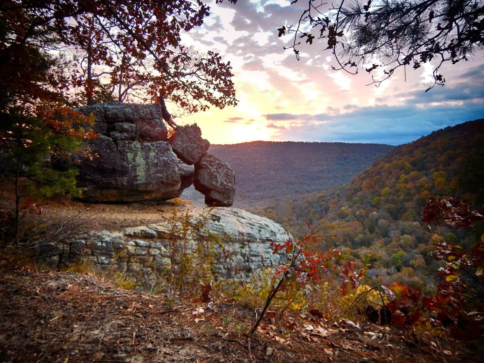
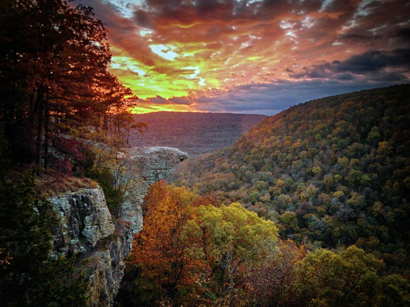
3. Hawksbill Crag
Length: 3 Miles Total | Difficulty: Moderate | GPS: 35.899332704181305, -93.45804248225826
Also known as Whitaker Point, Hawksbill Crag is the most-photographed place in Arkansas. This iconic spot overlooks the beautiful Whitaker Creek and features a giant rock outcropping in the shape of a bird's beak. The opening scene in the movie “Tuck Everlasting” was actually filmed at Hawksbill Crag, and the area was shrouded in mystery even before then. This was the site of the disappearance of Haley Zegas, a 6-year-old girl who survived three days in the Buffalo Wilderness alone before she was found. Haley Falls is a seasonal waterfall there which was named after her.
How to Get There

I managed not to fall off the crag
Getting to the Hawksbill Crag trailhead is an adventure in and of itself. This trail is located in the Upper Buffalo Wilderness south of Ponca. You’ll need to take AR HWY 43 southbound from Ponca and keep left at the fork to turn onto AR HWY 21. After about two miles you’ll see a bridge. Just before the bridge, take the turn-off onto dirt road #9560. This is where the fun begins.
#9560 is one doozy of a drive. It’s a steep, near-vertical climb at some points. Many people have done this in two-wheel drive vehicles, but I had to put my truck in 4X4 during the ascent. The road is narrow, dusty, and treacherous. After six miles, you’ll reach the trailhead. There is a small parking lot, but this is a popular place. If there’s no room, park on the roadside near the trailhead.
Hiking the Trail
Stopping to take a rest on the trail
This out-and-back trail is around three miles round-trip. It isn’t particularly difficult, but I rate it at moderate because the terrain is quite rocky. You can easily twist an ankle on the way down, even though the elevation loss is only about 400 feet. The high bluffline and sheer cliffs present a hazard as well. There are no fences to keep you from playing on the gigantic boulders dotting the cliffside, which can be a boon—but it also means you need to be mindful of the 150-foot drop at the edge.
The trail meanders down from the parking lot in a zig-zag, passing over wet-weather creeks and a few sinkholes along the way. In the fall the foliage is thinner, allowing you to see the sunlight trickling down through the reds and yellows of Arkansas beeches.
As you near the bluffline, you’ll see empty space beyond the branches. This is peppered with queer geometric rocks twice heigh of your average man, and it’s the perfect place to stop for a picnic and take in the scenery. Autumn gives you a stunning array of colors in the valley below. Arriving in time for sunset will make them that much more beautiful.
The View
It was worth waking up early to catch the sunrise on Hawksbill Crag
If you want a million-dollar shot of Hawksbill Crag, plan to spend the night here in the backcountry. Sunrises are infinitely more intense than sunsets. There’s something magical about watching a pink and lavender sky turn slowly to vibrant orange with the coming day, and it’s worth sleeping on the rocky ridge to catch the sight.
The moment that light hits the valley is unexplainable. Many choose to sit atop the crag itself, but watching it from a nearby perch is the best way to do it. Hawksbill is almost prehistoric. It sits locked in time, an unshakeable constant despite the rest of the world moving on. Of course, there are modern things far more exciting than a simple rock. But there is nothing more resplendent than that sun cresting above the mountains to shine down on Hawksbill Crag.
Make sure to take pictures, but be mindful of other photographers. Hawksbill gets crowded on the weekend. Try to arrive on a weekday if you can, and don’t plan on being the only one there. If you want to hike with a bit more privacy, you can explore a small footpath at the end of the main trail. It disappears into the forest as the high bluffline melts back into thick trees.
Let Your Autumn Adventure Begin
Ready to get your hike on? There’s no reason to wait. These three trails can all be done in a single weekend with a bit of preparation. Make sure to bring your camping gear, but leave your worries at the door. The breathtaking scenery will make you forget all about the world back home, so start your immersion in the Ozarks today.
No comments added


Recent Stories
A Quiet Season of Opportunity March sits in the quiet space between winter and spring—when campgrounds are empty, bugs are blissfully absent, and the weather can’t quite make up its mind. For campers willing to plan ahead, it’s one of the most rewarding times to be outdoors. Fewer crowds, fresh landscapes, and a slower pace make this month ideal for intentional, low-stress adventures. Expect the Unexpected The biggest challenge of March camping is variability. One weekend feels like spring, the ...
March Break is a great time to get kids outside and enjoy early spring adventures. Shorter days and unpredictable weather make preparation key. Here are ten quick tips to keep your family safe, warm, and having fun: Layer Up – Dress kids in moisture-wicking base layers, warm mid-layers, and waterproof outer layers. Don’t forget hats, mittens, and extra socks. Warm Sleeping Gear – Use sleeping bags rated for cool temperatures and insulated pads to keep everyone cozy at night. Choose Kid-Friendly ...
